Cartography M. Sc.
Have you ever encountered the trouble of getting lost in a strange place or in a complex building? You may believe that navigation services can save you from frustrations. At the same time, you don’t want to become spatially illiterate, that is, someone who is afraid to move a step forward without navigational assistance. Finding your way in a digital forest is even more challenging because neither compass nor GPS works there. Don’t worry: Your sense of orientation in both physical and digital space can be learned in this international joint master "Cartography". The program is geared toward digital natives who want to know how to transform our world into different types of maps on different display media and make it accessible by everybody including the visually impaired. We call it "mapping for a sustainable world".
What you'll learn for your future?
The program covers knowledge of and competencies in the visual representation, analysis and exploration of the digital Earth, together with its spatiotemporal elements and circumstances. The content of the program focuses chiefly on methods and applications in the areas of data modelling, data analysis and the visualization of geographical information. Cartography is devoted, in particular, to answering complex questions relating to the spatiality of a globalized and digitalized society. As such, it considers how the cartographic visualization and analysis of our environment is gaining an ever greater significance in many disciplines – from environmental and climate protection to geology, spatial planning or agriculture and forestry. In addition to conveying the fundamentals of the discipline and its methodologies, the program concentrates on the readable, aesthetic, and user-friendly visualization of geographical data, as well as the development of new methods of representation in the area of modern cartography.
Graduates have in-depth competence and fundamental knowledge in the entire field of cartography. Students learn to master recent theories, methods and procedures connected to map production and map use in the context of modern cartography and geoinformatics. Graduates are capable of developing cartographic research projects and implementing them in a professional and economic way. They have the ability to capture, model, manage, analyze and visualize spatial data, can competently handle databases and geographic information systems and manage rule-based graphic data processing in all forms and for all user groups. They are able to master all publication forms and media, from print media to electronic multimedia including web-publishing. Graduates are in a position to strongly influence and shape cartography as an independent science with its own research and object of knowledge, but also with strong relations to earth sciences, information sciences and communication sciences. As Cartography is an international master program, it involves students from a wide variety of cultural groups. Participants, thus, not only develop theoretical, methodological and technical skills, but also social and intercultural competencies.
The Master degree opens up excellent professional opportunities on national and international levels, both in the private sector and in administration or research. Graduates can work for government authorities, for map and atlas publishers or for companies specializing in GIS, location-based services, or navigation systems. Further opportunities arise in the areas of town and landscape planning, environmental protection, disaster management, tourism, transportation, or telecommunications.
In addition, the completion of the M.Sc. qualifies graduates for the PhD program. Cooperation with the four universities provides graduates with access to an international research network and thus an optimal start to a career in science.
Type of Study: Full Time
Standard Duration of Studies: 4 Semester
Credits: 120 ECTS
Main Locations: Technical University of Munich (TUM, Germany), Vienna University of Technology (TUW, Austria), Technical University Dresden (TUD, Germany), University of Twente (UT, The Netherlands)
Start of Degree Program: Winter Semester
Application Period: Winter semester: 01.01. – 31.05.
Required Language Proficiency: English
Tuition Fees: for Students from Non-EU Countries
The program focuses on a comprehensive education in cartography and geoinformatics, in particular on spatial information technologies, mathematic principles of map making, spatial data handling, theories and technologies of visual analytics, geovisualization and communication of spatial information.
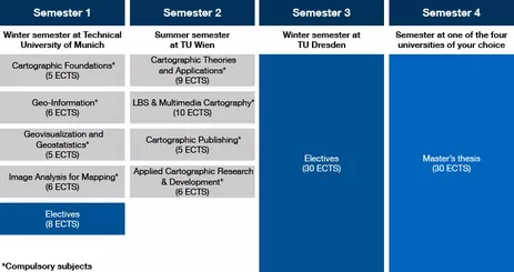
During the 1st semester at TUM, the foundations in cartography and geovisualization are taught. In the 2nd semester at TUW students gain knowledge in multimedia cartography, especially in web mapping, mobile internet and location-based services (LBS). Students specialize in mobile cartography and 3D cartography in the 3rd semester at TUD. During the first and third semester, online modules from the University of Twente are integrated in the curriculum. Students choose one of the four universities where they spend their fourth semester to write their master's thesis.
The curriculum is structured in complementary and consecutive modules. It is based on lectures, exercises, seminars and project works. In the beginning of the 3rd semester, an 11 days’ alpine field school within the module Georelief and Cartography takes place. A comprehensive collection of all details about the program can be found in the student handbook.

Students form a single group during the first three semesters and proceed together to the next university at the start of each new semester. The program begins in the winter semester every year at the TUM.
The four partner sites represent centers of excellence in the field of cartography, recognized at the European and global levels. The Chair of Cartography and Visual Analytics of TUM, the Research Division Cartography of TUW, the Institute of Cartography of TUD and the Faculty of Geo-Information Science and Earth Observation of UT complement each other in an ideal way. With a very high concentration of scientific competence in cartography, the exceptional program provides excellent job employment prospects in this interdisciplinary field.
All graduates are awarded a M.Sc. in Cartography and they receive a Joint Degree-certificate from the four partner universities. The program is funded by the European Commission within the Erasmus Mundus framework and awards scholarships to the best students from all over the world.
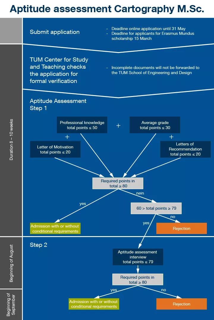
Please apply through the TUMonline application portal and upload your application documents.
More information on the application process to Cartography M. Sc. can be found on the Program's Webpage.
Before you go there, please first check whether you meet the entry requirements for the Cartography M.Sc. program and if you have all your documents for application ready. If you obtained your diploma from a country outside of EU/EEA or Switzerland, you need to apply additionally via uni-assist - University Application Service for International Students to make a preliminary evaluation whether you meet the entry requirements for the Master program at TUM.


